




Knowledge Hub


Key takeaways:
- El Niño is a complex weather phenomenon that can cause extreme weather events like flooding, storms and droughts across Asia, South America, Africa as well as the western Pacific
- A 'Super El Niño' is defined as occurring whenever Pacific sea surface temperatures are 2℃ hotter than average, which can have enormous effects on the global weather
- 2026 Pacific Ocean sea surface temperatures have risen to 3.05℃ warmer than their normal baseline, with sea temperatures exceeding 30℃ for the first time ever
- The 2026/27 El Niño might be the most devastating El Niño recorded
In 1892, naval officer Camilo Carrillo relayed a term used by Peruvian fishermen to describe the warm southern-flowing current that arrived around Christmas time and lasted for several months: “El Niño de Navidad”. Later shortened to just El Niño, it is one of the most complex and impactful weather phenomena.
Although it has been understood only relatively recently in a scientific sense, and despite originating in the equatorial Pacific Ocean, El Niño, is considered a global climate event that has arguably shaped the trajectory of histories from the French Revolution to the Great Famine of 1876-1878 in India.
Now, in 2026, there is a risk that a ‘Super El Niño’ threatens the lives of millions globally as well as devastating agriculture and the ecosystem. According to the National Oceanic and Atmospheric Administration (NOAA), there is an 83% chance that this winter will see the strongest El Niño event since the 1950s, potentially leading to the deaths of over 450,000 people worldwide
What is El Niño?
El Niño is a complex weather phenomenon that specifically refers to the warmer ocean temperatures that occasionally arise in the central and eastern equatorial Pacific Ocean. The opposite weather pattern is aptly named La Niña, in which cooler temperatures are observed. predicting when they’re likely to occur can be difficult, but the two weather variations generally last one year each and occur between two to seven years, with El Niños tending to be more severe.
Generally, eastern trade winds in the southern Pacific Ocean drive warm water currents towards Indonesia and northern Australia. However, in an El Niño year, the Pacific waters warm up, with sea surface temperatures potentially rising by 0.5℃ higher than their regular baseline, which can affect atmospheric conditions and have an accumulated effect on broader weather patterns. Rainfall becomes reduced in Indonesia and Australia, while conversely increasing in the rest of the tropical Pacific Ocean. The trade winds too, which normally blow from east to west along the equator, can weaken or even reverse direction and start blowing from west to east.
The effects of these weather changes are not only felt within the Pacific, but temperature and precipitation are affected on a global scale, leading to extreme weather events like flooding, storms and droughts across Asia, South America, Africa as well as the western Pacific.
What is the Super El Niño?
Once an El Niño crosses a specific threshold of intensity and into the ‘very strong’ category, it becomes known as a ‘Super El Niño’ sometimes also called a ‘Godzilla’ or ‘Behemoth’ El Niño. The scientific community defines a Super El Nino as occurring whenever Pacific sea surface temperatures are 2℃ hotter than average, which can have enormous effects on an atmospheric level.
An example of a historically destructive Super El Niño can be found in the 1997-98 season, which led to severe droughts in Indonesia and Malaysia, flooding in Peru, mudslides in California, tornados in Florida, the destruction of 16% of the world’s coral reef systems, as well as 23,000 deaths worldwide and an economic loss of $5.7 trillion USD globally.
Is this the worst El Niño yet?
The latest data shows that in 2026 the Pacific Ocean sea surface temperatures have risen to 3.05℃ warmer than their normal baseline, with sea temperatures exceeding 30℃ for the first time since records began. For context, the previously most severe El Niño in the historic 2015-16 year, ocean temperatures ‘only’ reached 29.8℃.
Although rare, there have been several Super El Niños in recorded history. As of writing, the forecast for the 2026/27 season does not look optimistic, with fears that it could be the most devastating El Niño recorded, peaking in December this year.
Global effects of the Super El Niño
Communities that have zero safety net are sadly going to bear the brunt of the destruction, as this El Niño also intersects with some of the largest humanitarian crises, as well as some of the most underfunded crises. Globally, poor communities are facing rising food, fuel, and fertiliser prices driven by conflict, displacement, and other climate events. Plus, these soaring costs are happening in conjunction with historic cuts to humanitarian aid budgets that have led to the gutting of life-saving programmes.
Indeed, we’re already seeing some catastrophic effects across the world right now. The eastern Pacific is having a record-setting hurricane season. Hurricanes are longer, and becoming more frequent and intense, with 22 named storms and 12 hurricanes, 10 of them being classed as major hurricanes. At one point in September, charged by the warm ocean waters, three simultaneous hurricanes were active at one time, with many of these hurricanes recording wind speeds of over 111mph. Plus, back in June this year, Tropical Storm Boris hit Mexico’s Pacific coast and caused an estimated $100 million USD in economic losses.
Over in Indonesia, which as mentioned before experiences less rainfall and warmer sea temperatures around El Niño years, the country is currently contending with its worst wildfire season since 2015. Since January this year, nearly 1.9 million hectares of land have been burned (nearly 12 times the size of London), leaving 175,000 people in Indonesia dealing with respiratory illness and 1700 people tragically dying from fire related causes.
The impact of El Niño on hunger
Global agriculture and food supply-chains are likely to take a massive hit from this year’s Super El Niño. Because El Niño shifts rainfall across the world, this can massively impact agriculture reliant on normal expected rainfall. Throughout history in India and Pakistan, farmers expect monsoon rainfall to descend between June to September, with archaeological evidence from 3000BCE highlighting techniques used by farmers and administrators in the regions to prepare for monsoon rainfall and adapt their approaches accordingly.
Disruption caused by El Niño, particularly severe ones, can drastically impact the ability of farmers in South Asia produce enough crops and perform well on an economic level – plunging many families into hunger and poverty. Right now, the expected monsoon rainfall has been 13% below average, with east and north-east Indian being around 26% drier than average and experiencing drought. And in Pakistan, a combination of global warming and El Niño has raised concerns that 2027 is likely to become the hottest year on record, leading to widespread drought in some regions.
Women like Farzana in Sindh, Pakistan are seeing the direct consequences of this. In 2025 her community endured a devastating heatwave. She described the toll of extreme weather on herself and her community:
“Our livestock are affected due to morbidity because of heatwave which lead to mortality. Mosquitoes are everywhere, and malaria is spreading. Pregnant and lactating women are the worst affected. They simply cannot bear these conditions.”

How Concern is supporting communities to build resilience to climate extremes
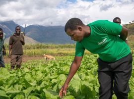
In Malawi, over 80% of people source their livelihoods from the land. And as such, Malawians are highly vulnerable to extreme weather, particularly intense El Niños as seen in the 2024 El Niño which brought severe dry conditions to the country and widespread food insecurity.
The UN is predicting that Malawi will experience strong impacts from the Super El Niño which will include “late and erratic” reduced rains, as well as an increased risk of flash floods.
Concern Worldwide has been in Malawi for over twenty years and in 2025 launched a Community Disaster Fund (CDF) to enhance community resilience to floods and other environmental hazards. One headteacher from the Nchere Primary School in a district affected by worsening flooding, spoke of the importance of the CDF in protecting his school.
“The looming threat of losing our valuable school buildings was a constant source of concern. However, our anxieties were alleviated by the intervention of Concern Worldwide under the CDF initiative. Through their support, the community was empowered to construct a protective dyke along the Nyamkotola River, effectively shielding our school blocks and teachers' residences from potential damage.”

In East Africa, in a region called the Mandera Triangle where Ethiopia, Kenya, and Somalia meet, we have reached 300,000 people across 105 communities in just three years with our Hanaano programme. The programme encompasses nutrition, livelihoods, natural resource management, clean water access, and other key areas of response into a single safety net to help families survive repeated climate shocks.
This holistic approach helps incredibly vulnerable communities reduce its losses, secure its food supply, and survive on the frontlines of the climate crisis.
To learn more about Concern’s efforts in building climate and disaster resilient communities, take a look here.


